Comparison between the archaeological remains of the Roman colonial center of Timgad and the Wari military center of Pikillacta will help us to explore how Imperial domination over colonial conquests was universally cemented through distinctive architecture and urban planning, designed to signify political control and organization.
With most Empires employing a ‘divide and conquer’ strategy,
architectural assimilation manifested the Empire’s commitment to a permanent
physical presence in their territories. Sites like Timgad and Pikillacta demonstrate
their respective Empire’s ability to establish monumental, intrusive centers
within culturally and spatially remote populations. Imperial control is reinforced through a uniform
representation of the resources, prestige and goods offered by the ruling
state—the Empire must represent a compelling image of what should be desired
and valued by the conquered society in order to promote co operation.
Hierarchal ideologies were intentionally incorporated into a
colony’s layout and buildings in order to sustain relations of dominance
between the Empire and its conquests. This transparent manipulation of space
imposes power structures which will further be explored and compared in our
case studies.
The respective archaeological sites demonstrate a universal argument for the controlled organization of colonial urban development. As evident from aerial views, both Empires applied an effort to manipulate the natural terrain of these colonies to adhere to a strict grid-plan. The manipulation of these foreign landscapes is consistent with the Imperial manipulation of its inhabitants through architectural medium. Traffic is controlled and regulated, hierarchal space is imposed, and iconographic ideals of the Empire manifests itself through a spatially organized power. It is through architectural assimilation and intimidation that the crucial unity of an Empire is preserved in its remote colonies.
The respective archaeological sites demonstrate a universal argument for the controlled organization of colonial urban development. As evident from aerial views, both Empires applied an effort to manipulate the natural terrain of these colonies to adhere to a strict grid-plan. The manipulation of these foreign landscapes is consistent with the Imperial manipulation of its inhabitants through architectural medium. Traffic is controlled and regulated, hierarchal space is imposed, and iconographic ideals of the Empire manifests itself through a spatially organized power. It is through architectural assimilation and intimidation that the crucial unity of an Empire is preserved in its remote colonies.
Timgad
Timgad was founded as a military colony by Roman Emperor
Trajan. The land was originally granted to veterans as compensation for years
of enduring harsh military service. Created ex
nihilo or ‘out of nothing,’ this site illustrates Roman urban planning at
its height: the square enclosure, with its strict orthogonal design and
perpendicular roads manipulates the elevated landscape to follow a precise grid
organization. The colony was
strong and prosperous, serving to maintain cultural dynamics and demonstrate Roman
ideals on African soil.
 | ||||
Figure 1: Timgad Entrance, Algeria.
|
 |
| Figure 2: Plan of Timgad, ~100 BC |
Pikillacta
This Wari military outpost is consistent with the Roman
necessity for military structures to have controlled and mathematical
organization. The various
provinces of the Wari Empire were protected by military instillations that
enforced power over local leaders, who were allowed to retain control of an
area if they agreed to join and obey the Wari Empire. The construction of large sites like Pikillacta marked a
threat of power to intimidate colonies.
This highly segregated space has various complementary sectors including
administration, ceremonial, roads and defense systems to impose aspects of Wari
socio-political hierarchies on external communities.
 |
| Figure 3: Pikillacta, Interior. Wari manipulation of space to force specific routes and adhere to grid design. |
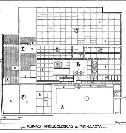 |
| Figure 4: Pikillacta, Plan. Middle Horizon. |
1. Hirst, Kris. “Andean Society call the Wari Empire,” Achaeology Sites and Places. http://archaeology.about.com/od/wterms/qt/wari_empire.htm
2. McEwan, Gordon. “Some Formal Correspondences between the Imperial Architecture of the Wari and Chimu Cultures of Ancient Peru.” Latin American
Antiquity. Society for American Archaeology, 1, 2 97-116, 1990.
2. McEwan, Gordon. “Some Formal Correspondences between the Imperial Architecture of the Wari and Chimu Cultures of Ancient Peru.” Latin American
Antiquity. Society for American Archaeology, 1, 2 97-116, 1990.
3. Schreiber, Katharina.
“Conquest and Consolidation: A Comparison of the Wari and Inka Occupations of a
Highland Peruvian Valley.” American
Antiquity, 52, 2, 266-284. 1987.
4. Thomas, Edmund. "Part I: Monumental Form." Monumentality and The Roman Empire: Architecture in the Antonine Age, Oxford University Press, 2007.
5. Tung, Tiffiny A.
“Violence and Rural Lifeways at Two Peripheral Wari Sites in the Majes Valley
of Southern Peru.” Andean Archeaology III.
435-467, 2006.
IMAGES
Figure 1: http://www.timgad-voyages.com/download/images/atv04.jpg
Figure 2: http://aureschaouia.free.fr/webgallerie/galleries/archive-algerie/plan-timgad2.jpeg
Figure 3: https://blogger.googleusercontent.com/img/b/R29vZ2xl/AVvXsEjonQBAYly86IR0_Av3LpnNGUh0LF0HA946HhN4fEt1hBOCjJ0HLfL8l0wCW_3YEWWjahS3JYURktjgiJmLefomVw38LQhAZoXtrafkQNIx0lSA_EEat6_x4rcTcSos4PeJZUfvAUJIdBY/s1600/pikillacta02-1.JPG
Figure 4: https://blogger.googleusercontent.com/img/b/R29vZ2xl/AVvXsEhXx5jiun4uuYD4G86QavbWaz9a-BZnUsAZxw82sd9COPKVGIlJ2oE-BTUbjbW72UmBEdza_CJWAX02ugkrMN2VUCgl1_PMNXKFDvloB63eZOWZUCDQV7okf5icPuFKRkji1g0XD2A6wNpI/s1600/2.17timgad.jpg